At 7,570 metres, Gangkhar Punsum, on the border between Bhutan and Tibet, is Bhutan’s highest mountain. With no mountaineering allowed in Bhutan, it also holds the title of the highest unclimbed peak in the world. The name, Gangkhar Punsum means “White Peak of the Three Spiritual Brothers.”
The start and end point for the trek to the base of Gangkhar Punsum is Bumthang, in central Bhutan. Bumthang can be reached by a long drive from Paro or Thimphu. Note that, currently, the road between Phobjikha and Bumthang is under reconstruction, making driving slow and, if it has been raining, hazardous in places. Alternatively, a short 40 minute flight from Paro to Bumthang operates regularly during the trekking season. Some guests choose to drive in one direction and fly in the other.
The trek route starts from the small village of Zhabethang and winds its way north, through some of the country’s most remote and least trekked valleys. Trekking days are typically shorter than on some of Bhutan’s better known treks, allowing time in the afternoons to relax in camp or explore further up the valley. The trek route crosses one pass and includes a night camping at close to 5,000 metres. As with any multi-day trek in Bhutan, we recommend that you are fit and ideally, have had high altitude trekking experience.
Day 1: Khathang – Gophu: 16 kms.
 From our hotel in the Bumthang valley, we will drive north, past the village of Toktu Zampa. Following the Chamkhar Chuu (river) north, past farmhouses, a mani wall, Buddhist shrines and the 7th century temple of Nga Lhakhang, we pass through the village of Zhabethang (Shobthang). Not far from the village, we will meet our horses and trekking crew. We will walk from here.
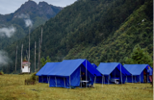
After about half an hour, we reach an army camp, at Khathang, where our trekking permits will be checked. The trail follows the river through a bamboo forest, with the valley gradually narrowing as we continue north. Many small streams cross the path and we may meet local herders tending to their yaks. We will camp in a clearing next to the river.
Overnight Camp – altitude 3,276 m
Day 2: Gophu – Tsampa: 11.5 kms
From Gophu, the valley continues to narrow and, as we ascend, the vegetation becomes more alpine. We cross 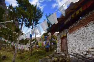 numerous streams as we follow the river. We will pass through a small army camp at Tsampa, set on a hillside opposite a temple that is looked after by the local herders. Our campsite, is next to the Mela Chuu river, just below the temple.
Overnight Camp – altitude 3,675 m
Day 3: Tsampa – Shingo: 12 kms.
 Leaving Tsampa, we set off past a small settlement of yak herders’ huts, known as Tsawuu. A short, but steep, climb, through a beautiful forest, brings us to 3,900 metres and some yak gates, built by local herders to keep their yaks from wandering too far. We then leave the forest behind to walk next to the river. Our campsite is at Shingo, a few stone huts above the tree line. Today is a shorter walking day to allow for acclimatisation and we should reach camp by lunch time.
Overnight Camp – altitude 4,209 m
Day 4: Shingo – Bamurpa: 8 kms
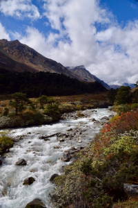
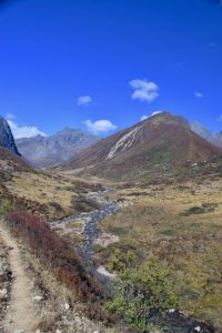
As we continue up the valley, the terrain becomes more rocky and we gain altitude during the day. If the weather is 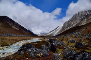 clear, there are views, along the route, of several snowy peaks at the head of the valley.
Camp is at Bamurpa, a meadow, next to the river. Depending on our arrival time, there may be time to hike further north, to view the glacier that comes down from the mountains.
Overnight Camp – altitude 4,490 m
Day 5: Bamurpa – Zhegephu: 11 kms.
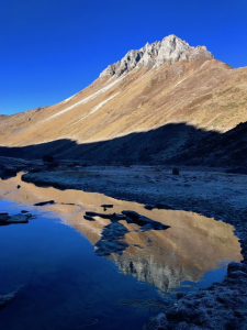
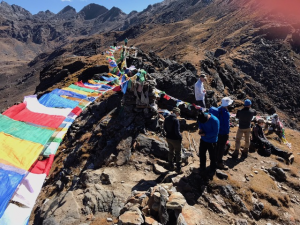
 Today is one of the highlights of the trek. From our campsite, we continue north for a short time to a point where the river is shallow and we can wade across – there is no bridge here. Once across the river, we climb a ridge on a steep switch-back trail into another valley and continue climbing into a wide bowl with the snowy flank of Gangkhar Punsum filling the horizon. A cairn and some prayer flags mark the entrance to the valley.
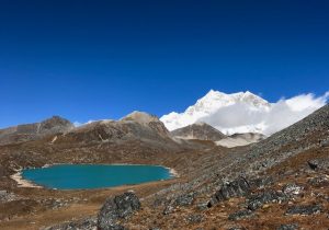
There are some yak herders’ hut in a meadow: this will be our highest camp of the trek at close to 5,000 metres. This afternoon, relax in camp and admire the view or climb up one of the surrounding high ridges for spectacular views of Gangkhar Punsum and many glacial lakes.
Overnight Camp – altitude 4,994 m
Day 6: Zhegephu to close to Shingo: 13.5 kms
If the weather is clear this morning, our crew will wake us early to watch the sunrise over Gangkhar Punsum.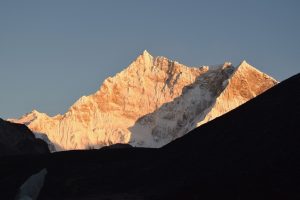
From the campsite, we will walk up to one of the ridges to explore the many glacial lakes close to the base of the mountain. We will then retrace our path, back to the camp, from where it is a long, easy descent to the main valley. We emerge opposite our campsite at Bamurpa, where we turn right and follow the river back down the valley close to where we camped at Shingo.
Overnight camp: altitude 4,209 m
Day 7: Shingo – Tsampa: 10.5 kms.
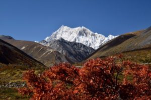 Day 7 begins with an easy descent down the valley, through beautiful forests as we leave the snowy bulk of Gangkhar Punsum behind. We will pass by the herders’ huts at Tsawuu and may see the herders rounding up their yaks to take them to lower pastures for the winter.
We return to our campsite below the temple at Tsampa.
Overnight camp altitude – 3,675
Day 8: Tsampa – Tsho Shap: 8 km
 A short distance from our campsite at Tsampa, we turn right, into a side valley and begin climbing on a series of steep switchbacks. Looking back up the valley, there are stunning views of high snow covered peaks in the distance, as we walk below towering cliffs. The trail opens out into a meadow and from there, climbs gradually, high along the side of the valley.
We climb back above the tree line, and up to a beautiful glacial lake, called Tsho Shap, at 4,220 metres. Camp is next to the lake.
Overnight Camp – altitude 4,420 m
Day 9: Tsho Shap – Tashi Sa: 10 kms
 Today, we will climb up from our lakeside campsite to the only pass of the trek. We begin by walking around the edge of the lake, crossing several streams. The climb to the Thole La (4,730 metres) takes about two hours from camp. On a clear day, the views stretch in all directions as we give thanks to the local deities with the traditional shout, at a pass, of “Yogaglo.”
A steep descent leads down from the pass to the Thashi Chuu valley. We follow the river and will camp close to a yak herder settlement before the bridge at Labrong.
Overnight Camp – altitude 4,117 m
Day 10: Tashi Sa – Chokchum: 13 kms
 If the herders are in their camp, there will be a lot of activity this morning as they round up their yaks and begin milking.
Our walk begins with a descent to a fork in the trail. We will turn left, over the bridge and follow the path towards Dur village. The trail here can be muddy and there are many short climbs and descents before we arrive at a clearing known as Chokchum for our final night’s camp.
Overnight Camp – altitude 3,247 m
Day 11: Chokchum to Dur: 13 km
Much of the final day’s trekking is through forest, next to the river on a muddy trail that has both climbs and descents. There is a last steep descent and then the farmhouses of Dur come into view. Our transport will be waiting for us at Dur. We will farewell our horsemen and crew and drive the short distance back to our lodge in Jakar.