The Snowman Trek is often described as “the toughest trek in the world”. Long trekking days, altitude, unpredictable weather, isolation, high passes and long distances make for a challenging combination. But, despite the challenges, trekkers are rewarded with views of some of Bhutan’s most remote and stunning scenery. Starting outside Paro, the trek sweeps in a wide arc along Bhutan’s northern border with Tibet, crossing the isolated Lunana plateau, before turning south-east to finish at either Sephu, near Trongsa, or further east, in the Bumthang Valley. The route described here is the longer, Bumthang version.
Please note that this is a strenuous trek involving many long days of walking. It crosses several high passes, most over 4,000 metres and three over 5,000 metres. It is not for the faint-hearted. Detailed trek notes, with approximate distances and walking times, follow below. Where trek distances for a single day are long, the walk for these days can be split into two, with an additional night’s camping. We also recommend including an additional day as a “buffer” in case of adverse weather or difficulties with pack animals.An excellent level of fitness, and previous high altitude trekking experience, is essential.
Day 1: Drive Paro to Shana.
Trek Shana – Soi Thangthangkha: distance/walking time 18 km/6-7 hours.
 We will drive to Drukgyel Dzong, a ruined monastery, now under reconstruction, at the end of the Paro valley. From there, we follow a farm road, through a narrowing valley of rice fields, passing many traditional farmhouses along the way. We meet our trekking crew and packhorses near an army outpost, at an elevation of 2,890 metres.
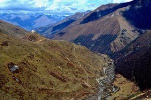
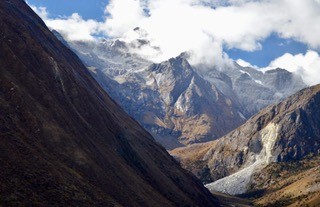
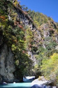
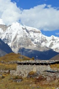
From the army camp, we follow the Paro Chhu valley on an undulating, rocky, and sometimes muddy, trail. Bridges, adorned with prayer flags, cross the river in several places. At a fork in the trail, keep right: left leads to Tibet. After climbing gradually through a forest, with many short climbs and descents, we arrive at our campsite, in an open meadow. The summit of Mt Jhomolhari can be seen from the camp.
Camp altitude 3,575 metres.
Day 2: Soi Thangthangkha – Jangothang: distance/walking time – 17 km/5-6 hour
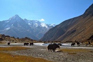
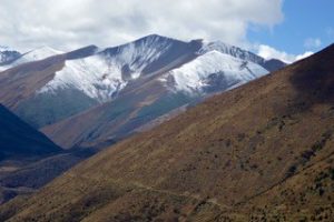
The day starts with a gradual climb through alpine vegetation, until the landscape opens up into a wide high valley. We are surrounded by high ridges and snow-capped mountains all the way to Jangothang. We may com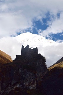 e across yaks and yak herder camps and will pass through small clusters of houses.
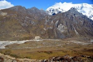
Thirty to forty minutes after the village of Dangochang, which has a small school, we will arrive at Jangothang. This is Jhomolhri base camp, a flat meadow overlooked by the ruins of an ancient dzong. If the weather is clear, there are stunning views of Mt Jhomolhari and Jitchu Drake, both imposing snow-covered peaks.
We will relax at the campsite for the rest of the afternoon or visit the ruined dzong.
Camp altitude 4,080 metres
Day 3: Jangothang halt
Today we will walk up the side valley, following the yak trails that weave along the valley slopes, to the base of Mt Jhomolhari. Climbing to the top of the moraine, we walk along a ridge, overlooking the glacier that snakes down from the mountain. The side-trip to see the glacier takes 5-6 hours return and we will have a picnic lunch on the way.
Camp altitude 4,080 metres
Day 4: Jangothang – Lingshi village: distance/walking time – 21 kms/ 5-6 hours
 Leaving Jhomolhari base camp, we begin with a short flat walk before a steep climb, into a high basin. We may see yaks and marmots along the way. The trail levels for a while, until the start of a long climb to the Nyile La pass, at 4,890 metres. We pass a chorten, on a false summit, before the final ascent to the pass, where prayer flags flap in the wind.
 From the pass, we descend, steeply at first, then follow the valley to a chorten, overlooking Lingshi dzong and the mountains beyond. From a rise just off the trail, we look over Mount Tserim Kang and its glaciers to the north. The descent to our campsite follows a switchback trail through low bushes to the valley bottom. We camp next to the river.
Camp altitude 4,050 metres.
Day 5: Lingshi halt
 Today is a rest and acclimatisation day. You may choose to relax at the campsite or explore Lingshi village, which is a short climb out of the valley, on a steep trail, on the other side of the river. Not far from camp, up the valley, is Geu Goemba, a small temple tucked away on a cliff face, on the north side of the river.
Camp altitude 4,050 metres.
Day 6: Lingshi – Chebisa: distance/walking time – 16 kms/4-5 hours.
 It is a steep 45-minute climb from our camp to Lingshi dzong and the village of Lingshi. There is a Basic Health Unit and a school here.
From Lingshi, the trail meanders high along the side of the Mo Chhu valley, through alpine pastures. From a ridge at 4,140 metres, we descend into a side-valley, to the village of Goyul, with a small temple, set into a rock face. Depending on timing, we may take lunch in a farmhouse in Goyul village. From there, we trek high along the valley to reach a small pass, from which the settlement of Chebsia and its impressive waterfall is visible. We camp tonight in Chebisa.
Camp altitude 3,990 metres.
Day 7: Chebisa village to Shakyapasang: distance/walking time – 14.5 km/ 5-6 hours.
 From Chebisa village we start the day with a steep 450 metre climb. We will cross the Gombu La pass at 4,440 metres, from where there are spectacular views back towards Lingshi. The descent from the pass takes us down towards forested slopes to tonight’s camp by the river.
Camp altitude 4,000 metres.
Day 8: Shakyapasang to Robluthang: distance/walking time – 16kms/ 6-7 hours.
Today we have a climb of about 200 metres before the trail levels out for some time. Another short ascent brings us to the Jare La pass, at 4,785 metres, marked by cairns and prayer flags. Several snow-clad peaks, including Tiger Mountain, Kang Bum and Jitchu Drake, are visible from the pass on a clear day.
From the pass we descend on a rocky trail next to a stream, before climbing into a side valley and a small lake. We will camp nearby.
Camp altitude 4,160 metres.
Day 9: Robluthang to Limithang: distance/walking time – 14kms/ 6-7 hours.
 Today is a long day, with a steep climb to a high pass. We begin on a zig-zag trail that takes us up to a ridge at 4,400 metres, with views over a wide glacial valley. Marmots are often seen popping up out of their burrows here. On the climb up to the pass, the Sinche La, at 5,000 metres, noble rhubarb, a high altitude Himalayan plant standing up to a metre tall, covers the hillside; a distraction from the final 300 metre ascent to the pass.
Camp is in a cedar forest below the pass with a backdrop of Great Tiger Mountain.
Camp altitude 4,140 metres.
Day 10: Limithang to Laya village: distance/walking time – 9 kms/ 4 hours.
 We start with a walk through a forest, followed by a descent down to the river valley.
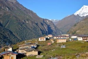
We then climb up to a ridge, from where we have views over Laya village, built on a shelving hillside, with Great Tiger Mountain in the background.
Camp altitude 3,800 metres.
Day 11: Laya halt
 Today we will explore Laya village, rest and do some laundry. There may be a chance to take a traditional Bhutanese hot stone bath at a local farmhouse.
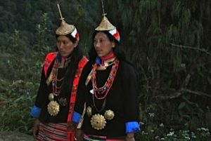
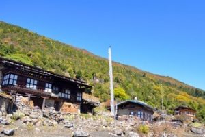
Laya has retained its own unique language and dress. The Layap women wear clothes woven from yak wool and a distinctive conical bamboo hat with a wooden pole protruding from the top.
Camp altitude 3,800 metres.
Day 12: Laya village to Rodophu: distance/walking time – 16 kms/ 6 hours.
 We say goodbye to the Layaps and make our way out of the village entry arch, through a stunning forest, following the valley of the Mo Chhu. It is a gradual descent to an army camp where we will have our trekking permits checked. About half an hour below the army camp, we turn east towards Lunana, on a narrow trail that leads steeply up through a forest. There are sweeping views along the Rodophu Chhu valley, from the undulating trail. There is a final climb before we descend to Rodophu, where we will camp near a stone shelter.
Camp altitude 4,215 metres
Day 13: Rodophu to Narethang: distance/walking time – 16 kms/ 6 hours.
 Today’s walk follows the trail behind the Rodophu shelter towards a false pass. After about three hours, we will reach the Tsemo La pass (4,905 metres).
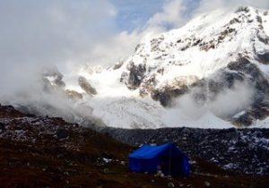
This afternoon, we continue across a high, exposed plateau, reaching the campsite at Narethang, in the late afternoon. This is our first high camp, at 4,940 metres, with the snowy peak of Gangla Karchung towering above us.
Camp altitude 4,940 metres
Day 14: Narethang to Tarina: distance/walking time – 16 kms/ 7-8 hours.
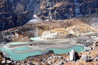
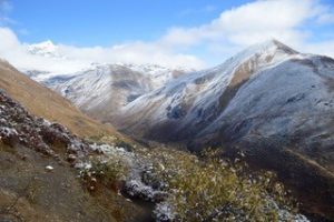
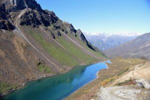
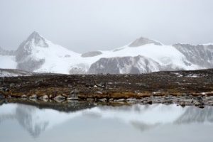
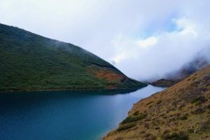
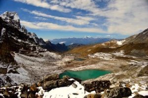 It is a short climb this morning to a high plateau and from there to the pass, the Karchung La (5,220 metres). The pass affords stunning views across the Lunana plateau and a turquoise glacial lake below.
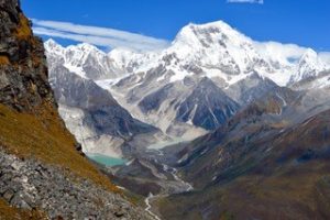 The trail descends steeply from the pass and then levels out as we follow the moraine. At the end of the moraine, the Tarina valley falls away to the north. There are spectacular views towards Teri Kang and its glaciers and glacial lakes.
A very steep descent, on a narrow, switch-back trail, takes us down into the Tarina Valley and a point where several streams meet, making the ground wet underfoot. We will continue along the valley bottom, past tall cliffs and beautiful waterfalls, to a flat camping place on the other side of the Tarina Chhu.
Camp altitude 3,940 metres.
Day 15: Tarina to Woche: distance/walking time – 14 kms/ 4 hours.
 The trail continues along the valley bottom before climbing steeping through a dense forest to the village of Woche, the first settlement since leaving Laya and no more than a few stone farmhouses. We will have lunch near the village before the afternoon’s gentle walk down to the campsite, close to the Woche Chhu
Camp altitude 4,160 metres.
Day 16: Woche to Lhedi: distance /walking time – 13 kms/ 4-5 hours
 From our campsite, we climb up past Green Lake to the Kesha La pass (4,666 metres) on a zig-zag trail, through low shrubs. Prayer flags and cairns mark the pass.
From the pass, we descend on a steep, rocky switchback, through the small village of Tega. The snow-covered Table Mountain dominates the horizon. The trail continues parallel 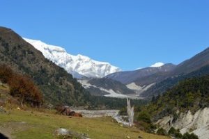 to the Pho Chhu, crossing a waterfall and dropping down to the riverbed. We cross and re-cross the numerous channels that wind through the valley, before a short but step climb on a muddy path to the village of Lhedi, where there is a school and Basic Health Unit.
Camp altitude 3,900 metres.
Day 17: Lhedi to Thanza: distance /walking time – 17 kms/ 5-6 hours
 Today is the flattest walk of the trek. We leave the village of Lhedi, following the Pho Chhu, past the administrative buildings for the Lunana district.
We reach a wooden bridge across the river. The trail to the right leads to Thanza, and the mid-point of our trek, while left goes to the small village of Chozo. If time permits, we will make a detour to Chozo and visit Bhutan’s most isolated monastery. We then return to the bridge and continue along the east bank of the river, crossing flat yak pastures, until a chorten marks the entrance to Thanza.
Camp altitude 4,100 metres.
Day 18: Thanza halt
 Thanza comprises several distinct settlements, watched over by the snow-covered 7,000 metre Table Mountain. This morning is an opportunity to rest and relax in camp, in one of the most isolated valleys of the Himalayas.
In the afternoon, we may visit some of the local farmhouses or walk further up the valley to view one of the many glacial lakes in this area.
Camp altitude 4,100 metres.
Day 19: Thanza to Zaram: distance /walking time – 22 kms/ 8-9 hours
 From Thanza, the trail climbs up a steep hillside to the top of a ridge. Looking back, we enjoy a panoramic view over the Thanza valley, Chozo and Table Mountain. We then turn into a side valley, where an impressive waterfall tumbles down a cliff face.
We will stop for lunch in a meadow, known as Djundje, which is surrounded by mountains. It is a long walk this afternoon, on an undulating trail, to tonight’s high campsite at Zaram, next to a river.
Camp altitude 4,870 metres.
Day 20: Zaram to Minchugang: distance /walking time – 16 kms/ 7 hours
 After leaving camp, we begin the long climb to Tsorim Lake on a rocky trail. On a clear day, snow-capped peaks reflect in the waters of the lake.
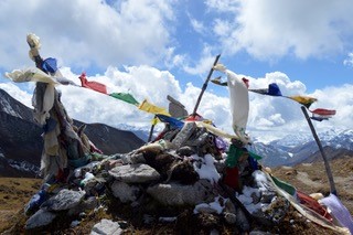
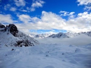
From the lake, we climb to the highest pass of the trek, the Gophu La, at 5,345 metres. We will add prayer flags to the many already strung between rocks and cairns, as we give thanks for our safe arrival at the pass.
From here we descend, over a moraine and across a rocky plateau to the ruins of a yak herders’ camp, known as Minchugang.
Camp altitude 4,210 metres.
Day 21: Minchugang to Uruthang: distance /walking time – 12 kms/ 7-8 hours
 Today is one of the most challenging days of the trek, with three passes to cross. We will start early, following a trail high above the Sasha Chhu, before a steep climb to the Phrodrang La (4,652 metres).
From here, we descend, before another steep, rocky climb to the 4,820 metre Saga La. On the approach to the Saga La, we pass by a stone hut built on to the side of a large boulder, with a lake below. When we reach the pass, we will be rewarded with panoramic views over snow-capped peaks and sweeping valleys, making all the effort worthwhile.
The descent from the Saga La is a welcome relief from the day’s climbing and the third pass, the Uruthang La, is a much gentler ascent. From there we will walk for another hour to an hour and a half, across a swampy meadow, before a short climb to a yak herder’s hut which marks the campsite at Uruthang.
Camp altitude 4,455 metres.
Day 22: Uruthang to Dur Tsachu: distance /walking time – 10 kms/ 6-7 hours
From Uruthang, we have a short climb to the only pass of the day, the Nephu La (4,495 metres), with its single cairn. Then, it’s all downhill, through alpine meadows, passing a lake, called Animo Tsho, in which a nun is said to have drowned. We may see blue sheep on the high crags 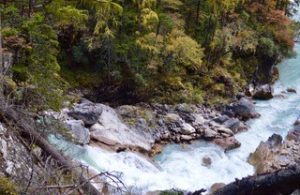 above us.
We descend below the treeline, following a stream through forest and rhododendrons. By lunch time we have reached a waterfall. We then continue along winding trails before crossing the river on a wooden bridge and beginning the climb up to Dur.
Dur hot springs comprise a series of simple wooden bathing huts built around natural hot springs of varying temperatures. After our many days in the mountains, bathing in the hot springs is bliss. We camp tonight next to the river.
Camp altitude 3,300 metres.
Day 23: Dur Tsachu to Tshochenchen: distance /walking time – 16 kms/ 8 hours
 Although we are nearing the end of the trek, today’s walk involves a relentless, steep ascent of more than 1,000 metres. We set off from the hot springs, past a yak herder’s hut in a clearing, before climbing through a forest to the Gongto La pass at 4,327 metres. After the pass, we walk along the shore of lake Djule Tsho before climbing again to the Jule La, our final pass of the trek, from where there are spectacular views. At 4,550 metres, we will have cl
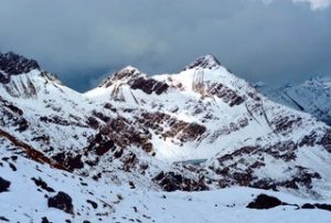 imbed 1,250 metres from our camp the previous night.
From the Jule La, we descend 600 metres, through yak pasture, to a wide river valley. We cross the river on a narrow wooden bridge to our last campsite at Tshochenchen.
Camp altitude 3,920 metres
Day 24: Tshochenchen to Jakar: distance /walking time – 25 kms/ 8-9 hours
We finish the trek with a long walk, on a rocky and often muddy trail. There are several river crossings and short ascents and descents through the forest, before we begin the long descent to the Bumthang valley and the end of our trek. We finish by crossing the river on a suspension village and arrive in the small village of Mechugang. We will say farewell to our horsemen and crew here before the short drive to our hotel in the Bumthang valley.